 "Akio Ohtori - RIP Oppo" (akioohtori)
02/04/2019 at 19:28 ē Filed to: akio ohtori, Oklahoma Adventure Trail, TQ Overland
 5
5
 14
14|
"Akio Ohtori - RIP Oppo" (akioohtori)
02/04/2019 at 19:28 ē Filed to: akio ohtori, Oklahoma Adventure Trail, TQ Overland | 5
| 14 |
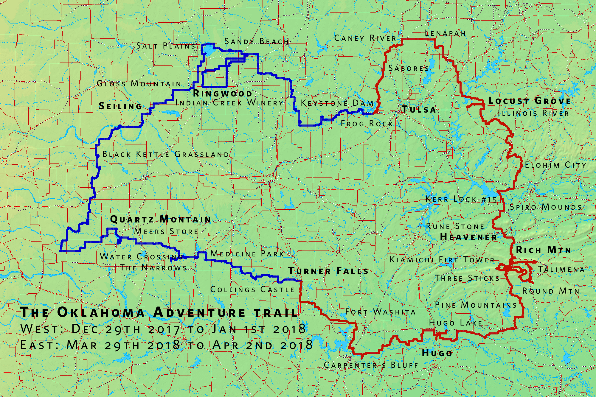
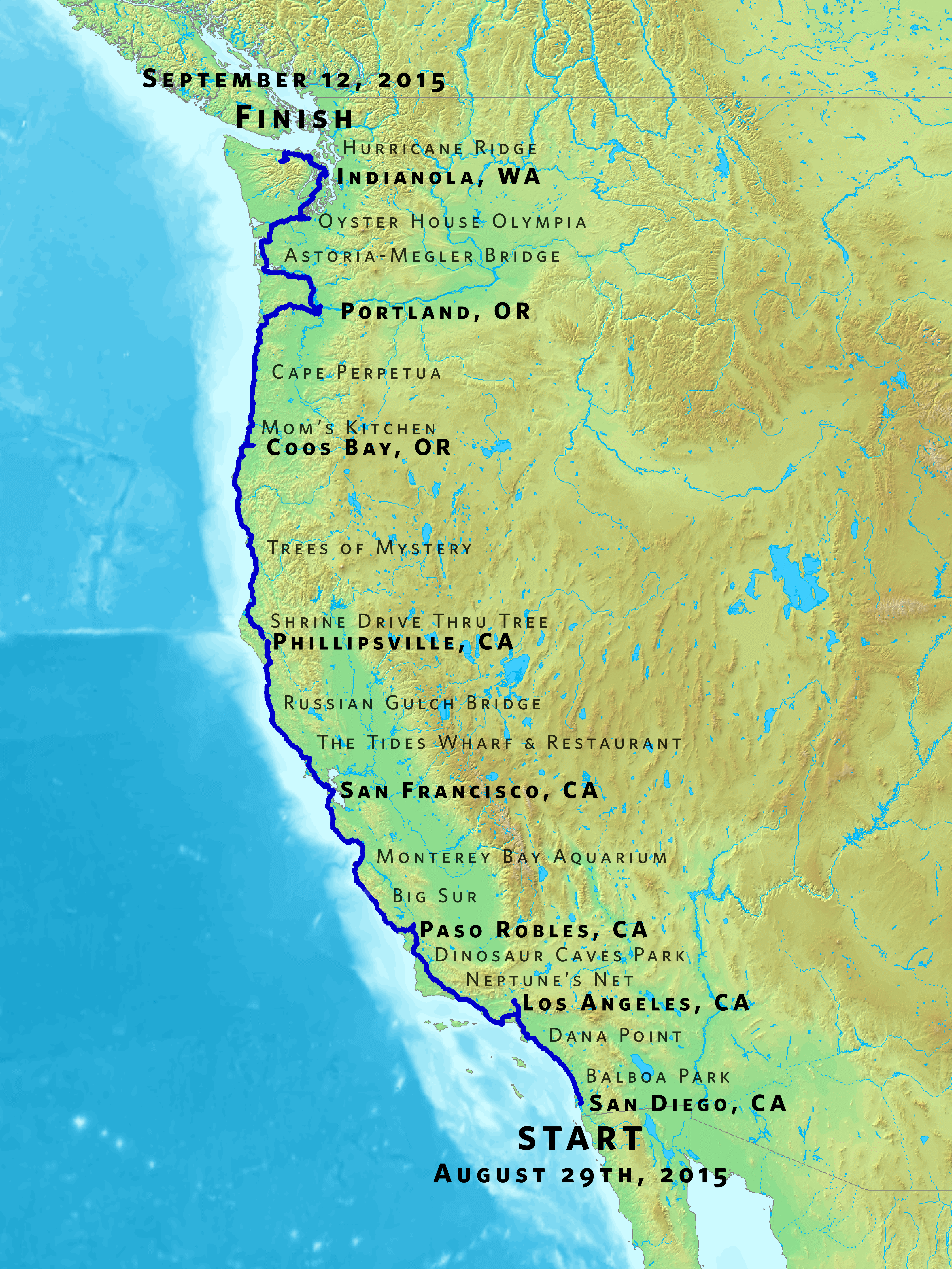
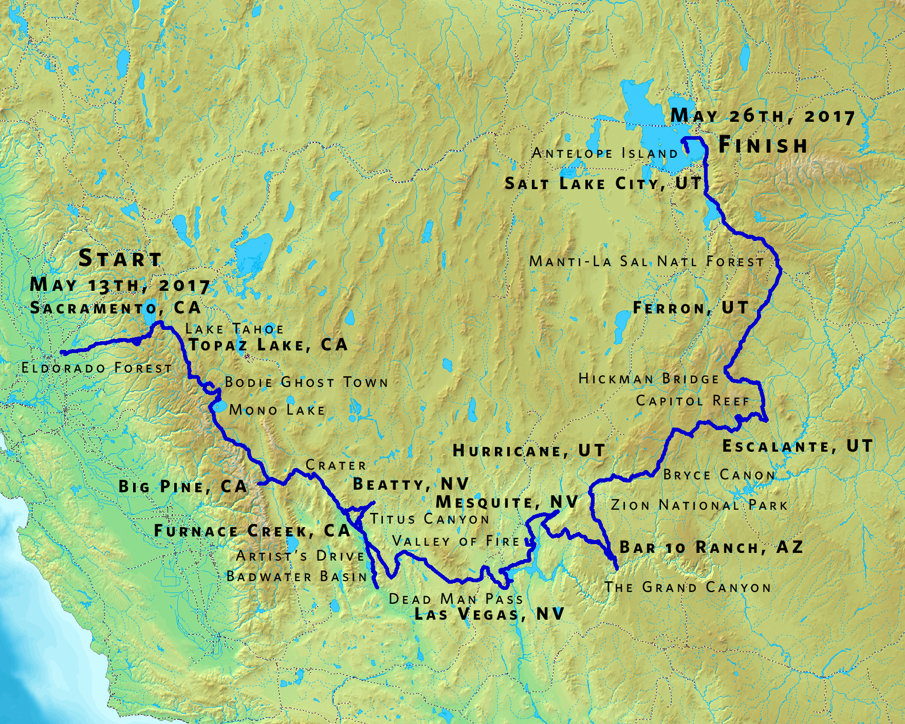
I wanted to get some trip maps framed with photos as a conversation piece and memorial to the road trips. I still havenít found a great way to make these maps, but I have found an acceptable way.
What I ended up doing was taking the ďas plannedĒ routes I had in Google Maps, modifying them to ďas driven,Ē and saving the links. I then used the service !!!error: Indecipherable SUB-paragraph formatting!!! to convert to, yup you guessed it, GPX files.
I took those GPX files and loaded them in to !!!error: Indecipherable SUB-paragraph formatting!!! and exported them as a PNG.† Sadly, the largest theyíll allow is 2000px by 2000px, but that appears to be enough to print an 8x12.
OAT was a little different as we already had the maps loaded into !!!error: Indecipherable SUB-paragraph formatting!!! , so I just updated those routes in CalTopo and directly exported the GPX files, then fed them into GPS Visualizer in the same way.† Here is the output:
Rather than relying on the labels in the GPX files, I then loaded the PNG into Photoshop and added them manually. Bold text is for overnight stays, normal for sights.
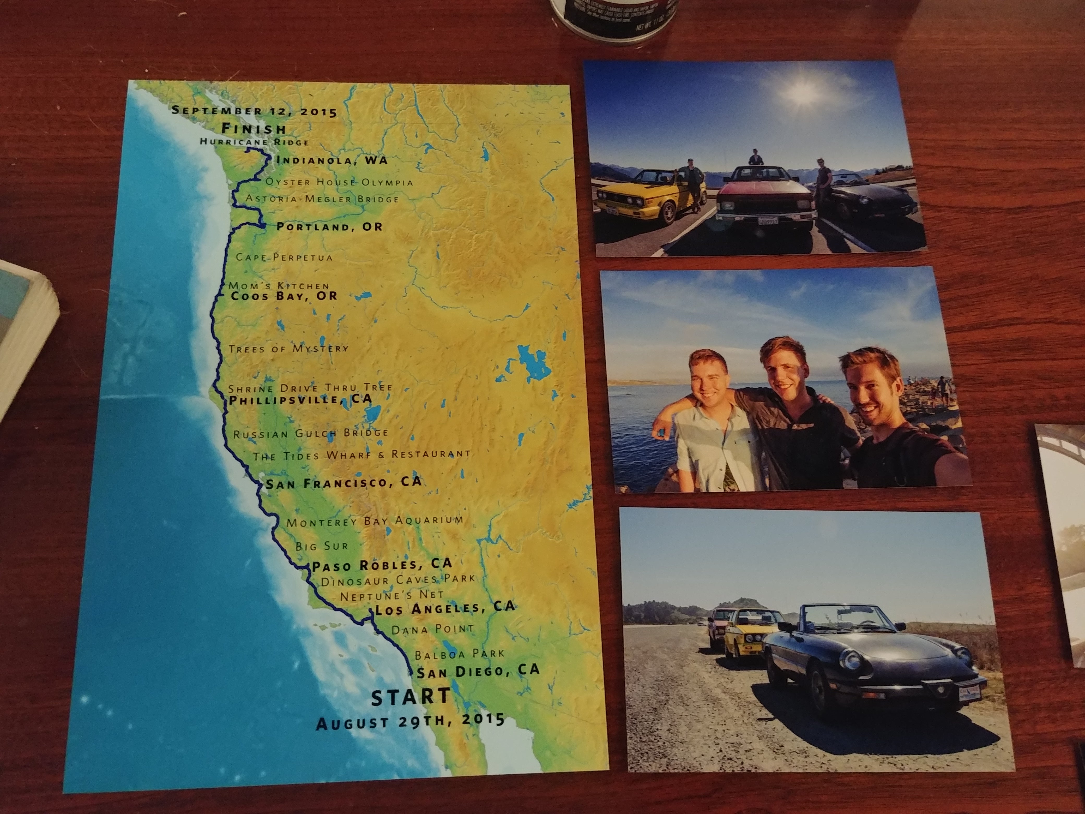
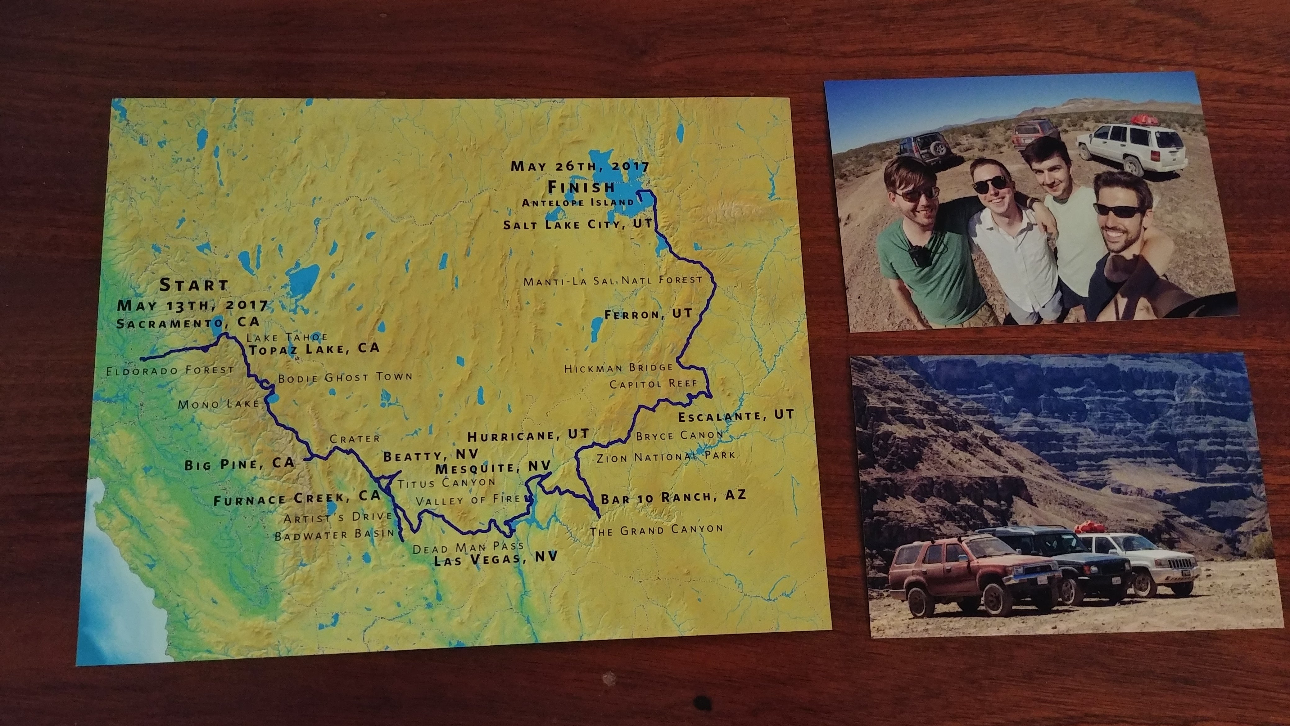
Iím mostly happy with how they turned out, and I must say they look
sharp
in print.
First two rounds are at the framers. Iíll drop off the OAT one when I pick those up.
 HammerheadFistpunch
> Akio Ohtori - RIP Oppo
HammerheadFistpunch
> Akio Ohtori - RIP Oppo
02/04/2019 at 19:31 |
|
why not use earth pro and import the gpx overlay?
 M.T. Blake
> Akio Ohtori - RIP Oppo
M.T. Blake
> Akio Ohtori - RIP Oppo
02/04/2019 at 19:38 |
|
Whoa! Super cool. Good job.
Is there a name for someone who is obsessed with maps? Iím one too.†
|
Akio Ohtori - RIP Oppo
> HammerheadFistpunch
02/04/2019 at 19:41 |
|
I started there, but iirc Earth prefers KML files and seems to deal poorly with maps of the size we're working with.
|
HammerheadFistpunch
> Akio Ohtori - RIP Oppo
02/04/2019 at 19:48 |
|
fair nuff
 TheRealBicycleBuck
> Akio Ohtori - RIP Oppo
TheRealBicycleBuck
> Akio Ohtori - RIP Oppo
02/04/2019 at 20:06 |
|
Those look pretty good!
If you want to dip your toes a little deeper into the world of professional mapping, there are a lot of free Geographic Information Systems (GIS) options and most of them will create production-quality maps.
https://gisgeography.com/free-gis-software/
Even the free ArcGIS Online will create some fantastic maps and online applications and they provide direct access to a variety of base layers, including USGS topo maps.
 AestheticsInMotion
> Akio Ohtori - RIP Oppo
AestheticsInMotion
> Akio Ohtori - RIP Oppo
02/04/2019 at 20:08 |
|
Your adventures are at least partially responsible for me deciding to fly down to California and drive a car home. Tha nk you sir!
 Just Jeepin'
> M.T. Blake
Just Jeepin'
> M.T. Blake
02/04/2019 at 21:33 |
|
Apparently cartographile is one term for it. Definitely applies to me too. Was quite sad when the last map shop in Indianapolis closed.
|
Akio Ohtori - RIP Oppo
> AestheticsInMotion
02/04/2019 at 22:45 |
|
How hard can it be? :-D
 vicali
> Akio Ohtori - RIP Oppo
vicali
> Akio Ohtori - RIP Oppo
02/04/2019 at 22:59 |
|
Too bad you donít know any GIS Technicians who do this kind of thing day in and day out for the last 17 years..
Y ouíve got gpx? Add them onto arcgisonline and see what they look like. Gpx to kml converters are online as well, then you can play in google earth.
How big is the final map? If you find a place with printing service you can probably get them plotted for a couple bucks.
Again, a real shame you donít know someone who sits beside an Designjet† z 6200 every day..
|
Akio Ohtori - RIP Oppo
> TheRealBicycleBuck
02/05/2019 at 11:11 |
|
Iíll take a look, thanks!
 davesaddiction @ opposite-lock.com
> Akio Ohtori - RIP Oppo
davesaddiction @ opposite-lock.com
> Akio Ohtori - RIP Oppo
02/05/2019 at 17:11 |
|
Very cool - they look great!
This is a thing, too:†
https://www.esri.com/en-us/arcgis/products/arcgis-for-personal-use
|
davesaddiction @ opposite-lock.com
> vicali
02/05/2019 at 17:15 |
|
Haha... We have a lowly old † T770 here , but we just picked up a newer Z5400.
|
vicali
> davesaddiction @ opposite-lock.com
02/05/2019 at 17:22 |
|
Iíve got the twins; two z6200 behind me.
My nightmare is a word doc sent to either of them...
|
davesaddiction @ opposite-lock.com
> vicali
02/05/2019 at 18:03 |
|
A common occurrence .